Trail Walking La Grave - Lac du Goélon - Refuge Carraud - Photo

Lac du Goélon - Refuge Carraud

 rapako
rapako

User

© OpenStreetMap contributors
Length
Length
10.9 km
Max alt
Max alt
2486 m
Uphill gradient
Uphill gradient
665 m
Km-Effort
Km-Effort  
19.7 km
Min alt
Min alt
1876 m
Downhill gradient
Downhill gradient
665 m
Boucle
Boucle
Yes
Creation date :
2020-07-09 07:19:28.0
Updated on :
2020-07-09 16:05:31.647

(0 Reviews)

Walking
Walking
4h30
Difficulty : Difficult

Scan this QR Code to open this trail in the SityTrail application

FREE GPS app for hiking

Logo SityTrail SityTrail

IGN / Geographical institutes

Download SityTrail from the App Store Download SityTrail from Google Play

Logo SityTrail SityTrail World

The world is yours!

Download SityTrail from the App Store Download SityTrail from Google Play Download SityTrail on Huawei AppGallery

About

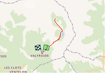
Trail Walking of 10.9 km to be discovered at Provence-Alpes-Côte d'Azur, Hautes-Alpes, La Grave. This trail is proposed by rapako.

Description

Il est préférable de partie de Valfroide plutôt que de s'arrêter au hameau "Les Hyères". Le chemin carrosable entre les 2 hameaux n'est pas intéressant et on mange la poussière des voitures qui justement montent jusqu’à Valfroide.

On a cherché en vain la passerelle qui se trouvait au nord du Refuge de Carreau pour passer de l'autre côté du Lac.

Elevation profile

Positioning

Country:
France
Region :
Provence-Alpes-Côte d'Azur
Department/Province :
Hautes-Alpes
Municipality :
La Grave
Location:
Unknown
Start:(UTM)
290283 ; 4993775 (32T) N.

Trails nearby

Trail Walking La Grave - L'aiguille du Goléon - Photo
Walking
tracegps

Walking

Very difficult
(1)
La Grave, Provence-Alpes-Côte d'Azur, Hautes-Alpes, France
9.1 km | 25 km-effort
5h 0min
No
Trail Walking La Grave - vallons de la Meije : lac Puy Vachère - Photo
Walking
GUIDE
nadinebondoux

Walking

Very difficult
La Grave, Provence-Alpes-Côte d'Azur, Hautes-Alpes, France
12.7 km | 27 km-effort
5h 44min
Yes
Trail Walking Villar-d'Arêne - SityTrail - Lac du pontet et l'Aiguillon - Photo
Walking

Walking

Medium
(1)
Villar-d'Arêne, Provence-Alpes-Côte d'Azur, Hautes-Alpes, France
5.2 km | 8.6 km-effort
1h 56min
Yes
Trail Walking La Grave - 2020-09-03 Marche Tour de la Grave au plateau d'Emparis par le Pic du Mas de la Grave (3 jours) - Photo
Walking
GUIDE
holtzv

Walking

Medium
La Grave, Provence-Alpes-Côte d'Azur, Hautes-Alpes, France
51 km | 88 km-effort
17h 56min
No
Trail Walking La Grave - 2020-09-03 Marche La Grave au Refuge du Pic du Mas de la Grave - Photo
Walking
GUIDE
holtzv

Walking

Very easy
La Grave, Provence-Alpes-Côte d'Azur, Hautes-Alpes, France
12.2 km | 23 km-effort
4h 58min
No
Trail Walking La Grave - 2020-09-06 Marche La Grave Gare de Peyrou d'Amont au Col des Ruillans - Photo
Walking
GUIDE
holtzv

Walking

Medium
La Grave, Provence-Alpes-Côte d'Azur, Hautes-Alpes, France
6.2 km | 15.7 km-effort
3h 30min
No
Trail Walking La Grave - Oisans : AR La grave au col de Ruillans (Glacier de Girose) par col du Lac .crea - Photo
Walking
PatDev

Walking

Difficult
(1)
La Grave, Provence-Alpes-Côte d'Azur, Hautes-Alpes, France
16.6 km | 41 km-effort
3h 32min
Yes
Trail Walking La Grave - Côte Rouge  - Photo
Walking
GuyVachet

Walking

Very difficult
La Grave, Provence-Alpes-Côte d'Azur, Hautes-Alpes, France
11.3 km | 23 km-effort
6h 6min
Yes
Trail Walking La Grave - 05 lac goleon - Photo
Walking
randodyssée

Walking

Medium
La Grave, Provence-Alpes-Côte d'Azur, Hautes-Alpes, France
14.4 km | 28 km-effort
6h 2min
Yes


Close
My subscriptions